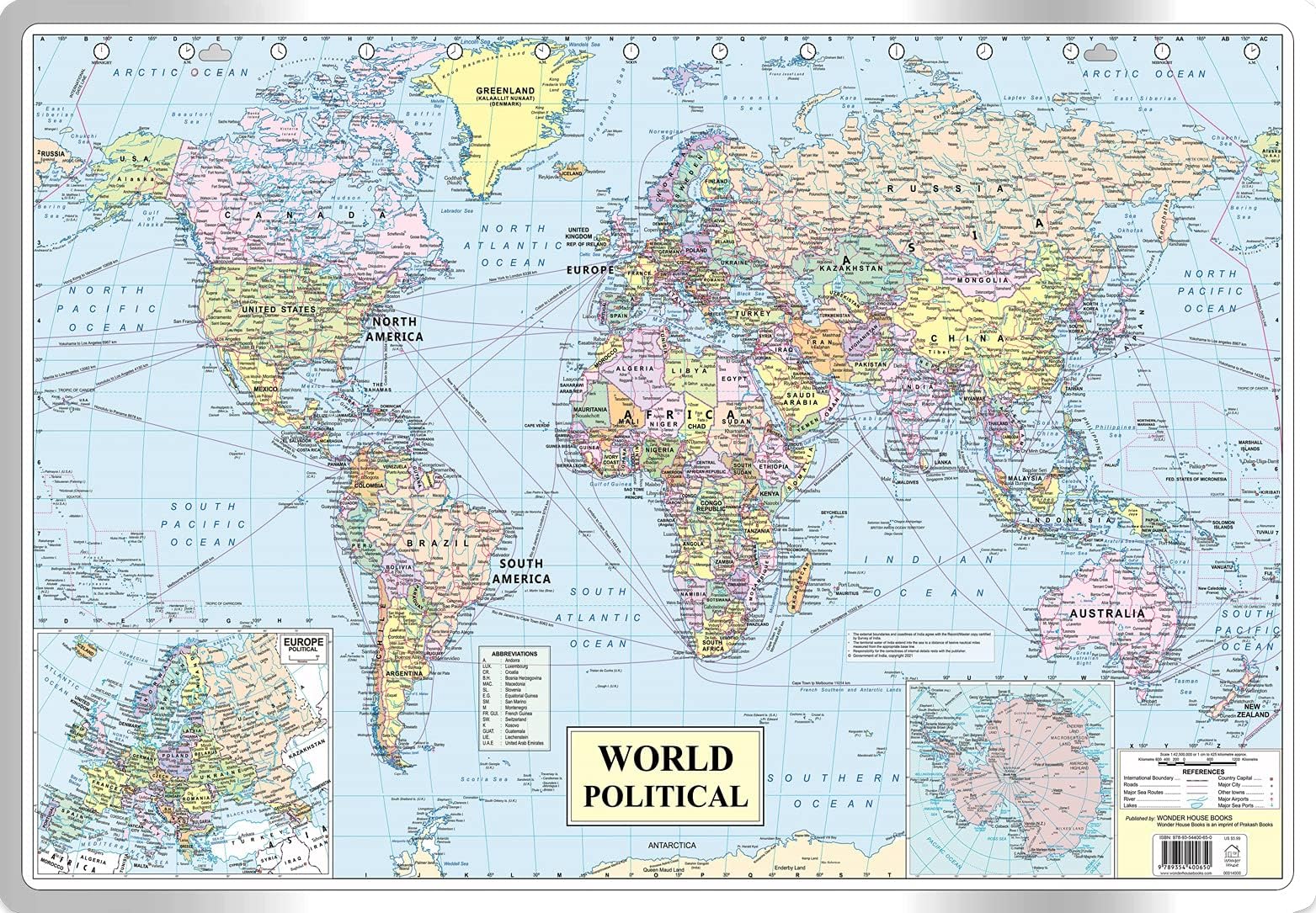
World Political Map : Map For Students (30 Inches X 20 Inches)
Product ID: 335561185
Buy anything from 5,000+ international stores. One checkout price. No surprise fees. Join 2M+ shoppers on Desertcart.
Desertcart purchases this item on your behalf and handles shipping, customs, and support to Brazil.
This is a syllabus friendly political map of the world meant for students. The student can study about the geographical locations of countries, their capitals and other important cities. It also depicts major shipping routes, sea ports, air ports and National highways. The map depicts the accurate flow of Rivers and lakes. These additional valuable information will help the student learn more about the world's Geography. The map is sturdy and can withstand lot of wear and tear without getting crumpled. The map is easy to hang on a wall with a nail. The dimensions of the map are 30 inches X 20 inches and have been approved by survey of India. This map is also useful for UPSC, SSC, Banking, Railways and other competitive exam preparations. Review: The durability of world Map - It was of good quality and durable for years Review: Nice - The World Political Map for Students (30 Inches X 20 Inches) is an excellent educational tool, especially designed for learners. Its clear, vibrant colors and well-labeled countries make it easy to read and understand. The map is printed on durable paper, ensuring it withstands frequent use, whether for school projects or personal study. Its compact size (30 x 20 inches) is ideal for classrooms, home study spaces, or offices, providing a clear view without overwhelming the space. Some users may prefer a larger size for more detailed exploration, but for most students, this map offers a perfect balance of detail and simplicity. Overall, it’s a valuable, affordable resource for anyone looking to enhance their knowledge of world geography.


| Best Sellers Rank | #15,475 in Books ( See Top 100 in Books ) #5 in Travel Tips #27 in Maps & Atlases #292 in UPSC Civil Services |
| Customer Reviews | 4.0 out of 5 stars 401 Reviews |
A**R
The durability of world Map
It was of good quality and durable for years
T**F
Nice
The World Political Map for Students (30 Inches X 20 Inches) is an excellent educational tool, especially designed for learners. Its clear, vibrant colors and well-labeled countries make it easy to read and understand. The map is printed on durable paper, ensuring it withstands frequent use, whether for school projects or personal study. Its compact size (30 x 20 inches) is ideal for classrooms, home study spaces, or offices, providing a clear view without overwhelming the space. Some users may prefer a larger size for more detailed exploration, but for most students, this map offers a perfect balance of detail and simplicity. Overall, it’s a valuable, affordable resource for anyone looking to enhance their knowledge of world geography.
S**P
Laminated Large Clear
wanted to buy one for my wall for long & I m happy I bought this one. It's totally laminated from front & back. Good quality. You can hang it on wall or use adhesive & paste it like me. Now we wl learn more about the world around and travel plans :) Thanks you Amazon for this reasonably priced world map. Will buy an atlas now
A**A
Thank you for delivery
Very bad product packing and delivery, found this aesthatically open before delivery. The delivery seems too smooth and before time.
I**A
Packing skill and use of common sense to protect such items from mutilation.
First of all thanks for the replacement, but sorry to state that the beautiful map has again been damaged because of faulty package. It has again been packed in an envelope shorter in size after crumbling in four layers as if it was a newspaper damaging the very surface of the otherwise beautiful print on the silver coated metallic sheet. As suggested earlier it should have been rolled and in its rolled form only the protective wrapping should have been done. It’s only the lack of simple skill and training of the packers. Packer didn’t use simple understanding. However since we need the map for use of our-school student we don’t intend to go for any other remedy. Thanks.
S**U
Good but bad packing
It came in very bad folded condition, the map itself is good, even the material is strong n sturdy but it was folded very badly for packing.
L**A
Worth every penny.
The map is printed on a thin aluminium like foil of great quality. The item is overall supurb. The packaging is the best part. The item was packaged in a large box big enough to fit a 42 inch flat TV. I was suprised to receive the order as i did not remember ordering anything that big. And as i opened the box, inside it was this map, unfolded and in perfect condition. This is the first time i have ever been excited to write a product review.
D**P
Good one
Clear and quality is good
C**M
Distorted with countries Wrong
Distorted map. I was really surprised to see that Israel is completely out of it. I'm not an Israeli, but I do know the map well, and I extremely dislike when because of politics they start faking a map. Even Luxembourg and Lebanon for example which are much smaller countries it says it clearly, while Israel not just that it doesn't say it, but the whole country they made it into a tiny little slither that you can barely see on the map though it is bigger than that as if it's just not there. I think it's just awful and shocking. I sincerely hope they'll stop making their fake maps.
A**E
Outdated information on the map
Authors placed the names of some Russian cities on the map as they were 90 years ago in Soviet age, but they didn’t forget to make Crimea part of Ukraine, even though Ukraine didn’t even exist back then.
Trustpilot
2 months ago
2 months ago